|
Head for the Hills
Story by Deborah Huso, Contributing Writer
|
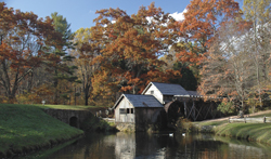
Mabry
Mill
|
If you’re wondering where to go to see the best fall
color, head to the changing elevations of Virginia’s mountains — where
scenic drives, peaceful hikes, and quaint mountain towns provide a
weekend’s worth of fall fun.
When it comes to viewing fall foliage, a drive through
changing elevations affords the best chance of catching color at its
peak somewhere along your route. The following suggestions offer not
just spectacular scenery, but a taste of Virginia mountain culture at
its colorful best.
Route 250: Charlottesville to Monterey
Before I-64 served as the main
westward route through the Blue Ridge Mountains, Route 250 was the major
byway, and today it remains a scenic, mostly rural route that one can
take west on a fall weekend
to enjoy the display of autumn leaves, high-elevation vistas, and side
trips through historic towns. From Charlottesville, 250 climbs the
slopes of the Blue Ridge gradually, bypassing rolling farmland with
gold-tinged grass and curling up the eastern slope of Afton Mountain.
Before cresting the mountain, be sure to stretch your
legs at the Rockfish Gap Country Store, a former fruit-packing shed
turned into a country store in the 1960s. In addition to a full array of
local antiques, paintings by Virginia artists, and a variety of home
décor and gardening items, the store also has a nice selection of wine,
cheese, ciders, crackers, and snacks, so pick up some picnic supplies
for the trip.
From Rockfish Gap, where one can also access Skyline
Drive and the Blue Ridge Parkway, 250 descends toward Waynesboro,
passing the remnants of old hotels and tourist attractions from the days
before the Interstate. From Waynesboro to Staunton, 250 becomes a busy
highway again, but don’t skip the drive. With its brick sidewalks,
iron-lamppost-lined streets, and eclectic architecture, Staunton lives
up to its name as “Queen City” of the Shenandoah Valley. It has five
National Historic Districts, some of which you’ll traverse as you glide
through downtown. Consider stopping for a picnic lunch at Gypsy Hill
Park with its duck pond, playgrounds, and scenic, shaded picnic areas.
From Staunton, 250 climbs again, this time into the
wild landscape of the Allegheny Mountains. As you head west, the fall
color displays are less and less interrupted by signs of civilization
until the highway enters the George Washington National Forest, curling
up the eastern slope of Shenandoah Mountain toward the remote reaches of
Highland County. Known fondly as Virginia’s Switzerland, Highland County
is perhaps the best spot in Virginia to enjoy fall foliage in solitude.
With one of the highest mean elevations east of the Mississippi, it is
also the least-populated county in the state with just over 2,500
residents. Here 250 follows the route of the old Staunton to Parkersburg
Turnpike, which was built in the 1830s and ’40s as part of a national
movement for improved roads, particularly into the nation’s backcountry
areas.
The best view of this drive is probably from the top
of Shenandoah Mountain at the Highland and Augusta County line, where an
overlook affords views to the west of as many as five ridgelines on a
clear day. Civil War buffs will appreciate this stop as well. There are
remnants here of trenches Confederates constructed in April 1862 in an
effort to defend the city of Staunton and the Turnpike from invasion by
Union forces from the west. A trailhead for the Shenandoah Mountain
Trail, a 30-mile ridge-hugging hike along the spine of the mountain, is
here as well.
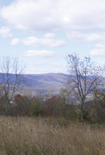
View from Sitlington Hill |
After descending Shenandoah Mountain via a curling
route west, Rt. 250 continues through tiny mountain communities like
Headwaters with its country store and post office and then toward the
more famous village of McDowell. Here, on May 8, 1862, Confederate
forces positioned on Sitlington Hill above McDowell fended off a Union
attack under Generals Robert Milroy and Robert Schenck. You can explore
some of the McDowell Battlefield via a 1.8-mile round-trip hike to the
top of Sitlington Hill or check out the exhibits at the Highland Museum
and Heritage Center in McDowell. The landscape at McDowell represents
the most well-preserved Civil War battlefield in the east, as it remains
virtually unchanged from its appearance in 1862.
From McDowell, 250 courses
along a scenic mountain stream, then up over Jack Mountain, the last
mountain of this trek, into the county seat of Monterey, elevation 3,000
feet. With a handful of craft, antique, and gift shops, Monterey offers
an opportunity for browsing as well as a chance for a home-cooked meal
before heading home again. Consider stopping by the 1904 Highland Inn on
Main Street for dinner or at least for a good sit in one of the inn’s
front-porch rocking chairs.
Skyline Drive: Thornton Gap to Swift Run Gap
Shenandoah National Park’s Skyline Drive is likely to
be busy during the peak fall color of October, but if you skip the very
northern end of the drive, which draws loads of visitors from the D.C.
metro area, you can avoid some of the crowds. Jump on at Thornton Gap,
just west of Luray via Rt. 211, head south through Marys Rock Tunnel, an
engineering wonder when it was built in 1932, and past the prominent
face of Stony Man Peak, a few miles to the south. An uphill but moderate
trail to Little Stony Man Cliffs (about a mile round-trip at milepost
39) offers a short hike to lovely views of Massanutten Mountain. And
when you come back down, you can enjoy lunch at Skyland, the lodge built
by naturalist George Pollock in the 1890s as a mountain retreat well
before Shenandoah National Park was ever created. Today the glass-walled
restaurant offers sweeping if sometimes hazy blue views of the
Shenandoah Valley.
View from Hawksbill
Mountain |
At milepost 42, there is a mostly level, scenic woods
walk through the former hemlock forest known as the Limberlost. The
hemlocks are mostly gone now, thanks to the invasive hemlock woolly
adelgid, providing a new landscape of low-growing successional forest
that is loaded with birds and white-tailed deer. If you’re lucky, you
might even encounter a black bear here. There are lovely mountain views
to be had from the summit of Hawksbill (elevation 4,051 ft.), the park’s
highest peak. The Upper Hawksbill Parking Area offers the most gradual
climb to the top, where one can see 180-degree views of the Shenandoah
Valley, Skyline Drive to the north, and the rolling landscape of the
Blue Ridge foothills to the east.
One of the most popular stops on the drive is Big
Meadows (milepost 51). Here the Park Service has recreated a mountain
meadow, which it keeps intact by burning off the brush every few years.
At dawn and dusk, the wide meadow, often peppered with wildflowers and
berries, is teeming with wildlife, mostly white-tailed deer by the
dozens. Black bears are also a common sight here, particularly near the
campground. Be sure to sample the park’s signature blackberry ice cream
at the Big Meadows Wayside.
If you’re up for a longer hike, the Milam Gap Trail,
just south of Big Meadows, provides hiking access to Camp Rapidan, the
former fishing getaway of President Herbert Hoover. An almost four-mile
round-trip hike, the trail has several scenic stream crossings, small
waterfalls and wading pools, and access to some of the historic camp
buildings if you time your hike to coincide with the ranger-guided
tours. (For tour times or to schedule a bus ride to the camp, call
540-999-3283.)
Another worthwhile spot, a little less traveled, is
Bearfence Mountain at milepost 56. For those who don’t mind a little
rock scramble, this round-trip hike of less than a mile offers
360-degree views at the summit. South River Falls (milepost 63) also
provides one of the park’s loveliest and least-traveled hikes. At two
and a half miles round-trip, this trail leads to a falls overlook where
the less adventurous can turn around, or one can continue down to the
base of the falls, where a rocky pool offers a wading spot and a cool
mist on warm days. Below South River is the park’s Swift Run Gap
entrance, where you can exit onto Rt. 33 toward Harrisonburg or
Stanardsville.
Blue Ridge Parkway: Tuggle Gap to Cumberland
Knob
While the Blue Ridge Parkway is undoubtedly the most
popular place in the state for a fall color drive, trying to hit the
Parkway on the peak day could be a challenge. The better option is to
pick a long stretch of the Parkway with varying elevations, thus
providing several opportunities for finding color at its height. To
avoid the crowds that typically flock to popular areas south of
Charlottesville and in the Peaks of Otter area, one can access the
Parkway at Tuggle Gap just west of Floyd off Rt. 8 and head south toward
Rocky Knob (elevation 3,572 ft.).
The Rocky Knob area of the Parkway is arguably one of
the most scenic sections in Virginia with its bald, grassy bluffs and
split-rail fences lining the road. While several overlooks here offer
ample opportunity for long-distance views to the east and west, consider
hiking a portion of the Rock Castle Gorge Trail, a 10.8-mile loop that
drops from the top of Rocky Knob to the depths of the gorge at 1,700
feet, thus providing nearly 2,000 feet in elevation change and varying
fall-color vistas.
From the Rocky Knob Campground, the trail descends for
three miles through a cove hardwood forest loaded with color. At the
base of this trail, the hike intersects an old roadbed, which follows
Rock Castle Creek. Here the hike is mostly level and the trail blanketed
with soft gold, amber, and scarlet leaves from overhanging maples, oaks,
and hickories. It passes through an old Civilian Conservation Corps
Camp, now used as a backcountry camping area, and also passes by an old
homestead (privately owned) and remnants of turn-of-the-century home
sites. This hollow was once occupied by subsistence farmers and cotton
and timber mill workers.
After 2.8 miles, the trail turns right, heads back up
the mountain, passing through a boulder field and a stand of towering
Catawba rhododendron. At Grassy Knoll, the hike parallels the Parkway
for the next 3.5 miles and is steep in sections, though the stunning
views of the gorge and surrounding boulder-heavy countryside are well
worth the extra effort. After descending Rocky Knob, the trail leads
back to the campground where you began.
While the Rocky Knob area has a scenic picnic area as
well as many grassy knolls perfect for enjoying an outdoor lunch, the
Chateau Morrisette Winery, just off the Blue Ridge Parkway near milepost
171, is another dining option. In addition to wine tastings (check out
their sweet mountain laurel varieties that taste just like fresh grape
skins), one can enjoy lovely mountain views from an elegantly set table
and lunch on a Black Angus burger topped with hickory-smoked bacon and
cheddar. Chateau Morrisette is one of Virginia’s premier wineries, now
producing more than 100,000 gallons of wines each year.
The most-photographed scene on the Blue Ridge Parkway
— historic Mabry Mill — is just south of Rocky Knob, and there is a
restaurant here as well. Restored in the 1940s and ’50s, the mill was
built in 1910 by Edwin Mabry, who operated it until 1936. This
water-powered gristmill also provides power to a wood-working shop as
well as to a sawmill. You can take a self-guided walking tour of the
mill complex or join a guided 30-minute tour. Guided tours run regularly
throughout the day on weekends from May through October, and in
fall-color season, you can also see various demonstrations here from
apple butter making to chair caning. The mill also has grinding
demonstrations as well as a blacksmith hard at work in the smithy.
After touring Mabry Mill, take a quick jaunt off the
Parkway to the little hamlet of Meadows of Dan, just south of the mill
complex. Fun spots to hit include the Poor Farmer’s Market, which
carries fresh produce, milled flour, deli meats and cheeses, garden
implements and décor, as well as ice cream and local crafts; and Nancy’s
Candy Company Factory Outlet Store, where you can pick up some chocolate
and fudge for the road. The Mountain Meadow Farm and Craft Market is a
relatively new addition to the shopping scene here and carries a variety
of locally made crafts at much cheaper prices than the gift stores on
the Parkway. In the fall, the market has a corn maze.
As the Parkway descends from Meadows of Dan, the
scenery gradually shifts from long mountain vistas to a largely forested
landscape of maples, poplars, chestnut oaks, dogwoods, and red oaks on a
high plateau. Ten miles south is an observation tower at Groundhog
Mountain, from which one can view the bull-shaped head of Buffalo
Mountain. The Park Service also has a display here on Appalachian rail
fences, including picket, snake rail, buck rail, and post and rail. Just
past Groundhog Mountain on the right is the preserved home of “Aunt”
Orlene Hawks Puckett, who lived in this little cabin until 1939 when she
was 102. A midwife, Puckett delivered more than 1,000 babies over the
course of her life and bore 24 children herself, though none of her own
lived beyond infancy.
As the Parkway continues south toward the North
Carolina state line, views are mostly of rural farmland, much of it
leased to area farmers by the National Park Service to maintain the
historic agrarian landscape. And just before the Parkway heads into
North Carolina is the Blue Ridge Music Center at milepost 213, a
must-stop no matter the season. While the Music Center has regular
evening entertainment at its amphitheater, you can also enjoy daily
mid-day concerts by area musicians right inside the museum, a perfect
way to settle in and relax before the long drive home.
For more information
Blue Ridge Parkway
(828) 298-0398
www.nps.gov/blri
Shenandoah National Park
(540) 999-3500
www.nps.gov/shen
Staunton Convention and Visitors Bureau
(800) 342-7982
www.visitstaunton.com
Highland County Chamber of Commerce
(540) 468-2550
www.highlandcounty.org
|
